by Steven Zettner, Editor
Availability of public space will strongly influence the success or failure of ‘transit-oriented’ development now emerging throughout the city. A few years ago, City Council in response to a report of the Families and Children Task Force directed the Parks Department to draw up a plan to provide a park within 1/4 mile of every residence in the urban core, and within 1/2 mile of areas beyond it. This was a badly needed first step. But the plan needs to be refined.

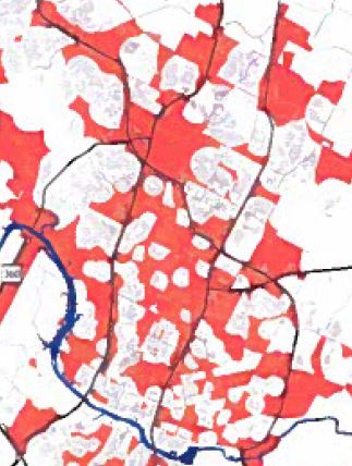
This map from the Parks Department’s urban park implementation plan shows the areas in red that are not within a quarter mile (urban core) or half mile (beyond urban core) of existing or potential park space.
There are flaws in the methodology used to develop this map. Practically any scrap of public land counts towards eliminating a “gap”, regardless of whether it is sufficient to serve a function appropriate to the area. In reality, the gaps are far greater than the map implies. The N Lamar/Rundberg area is a great example, where a handful of small peripheral parks or school grounds serve a dense community.
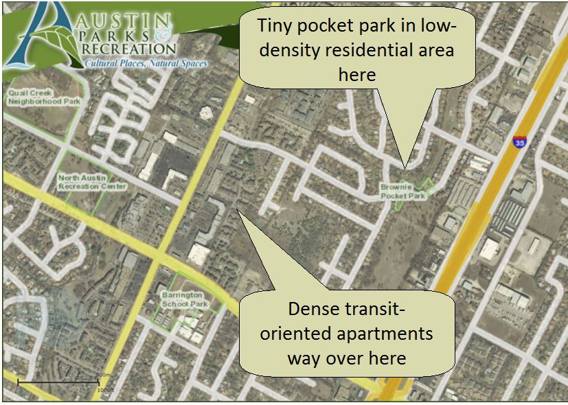
Some parks are located in quiet residential areas, but the gap analysis counts them as serving adjacent high density areas. This implies a random flow of people drawn into the residential areas, and away from transit or destinations. What needs to happen is the reverse – the park should be drawing people out of the residential areas, towards transit and shops. Drawing people INTO the quiet residential areas will cause nuisance problems, without contributing to the City’s ‘compact and connected’ goals.
Brownie Pocket Park – in the wrong place to support dense apartments along N Lamar
An example is Lucy Reed park in Allandale, which supposedly supports the entire Northcross mixed use district along Anderson. Pedestrians would have to cross school grounds into a quiet residential area – if they could even reach the park which is blocked from Northcross by a creek.
Another flaw is to put North Burnet Gateway and the Rundberg area outside the urban core, and thus not subject to the 1/4 mile access rule. NBG is intended to be a dense, highly walkable, transit-oriented district. It needs a denser distribution of parks. Rundberg is already one of the densest areas in Austin.
The plan should be reassessed with account of function. Some transit-oriented areas will need a community gathering space, others a small playground, a soccer field or a dog park, or creek-land buffering and trails for the perimeter of a community. Function and utilization, not chance availability of land, should determine park size and location.
Parks Department has been on a starvation diet for so long that there may not be much stomach to make the acquisition program more aggressive, when existing parks can’t even be maintained. But that thinking is a self-defeating one. We need to get the parks in the places where they contribute to connectivity and get amazing utilization – then the maintenance funding will come.

